


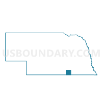
Nelson Precinct, Nuckolls County, Nebraska
About
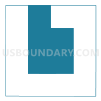
Outline

Summary
| Unique Area Identifier | 613659 |
| Name | Nelson Precinct |
| County | Nuckolls County |
| State | Nebraska |
| Area (square miles) | 180.57 |
| Land Area (square miles) | 180.28 |
| Water Area (square miles) | 0.29 |
| % of Land Area | 99.84 |
| % of Water Area | 0.16 |
| Latitude of the Internal Point | 40.20264540 |
| Longtitude of the Internal Point | -98.05927150 |
Maps

Graphs
Select a template below for downloading or customizing gragh for Nelson Precinct, Nuckolls County, Nebraska


Neighbors
Neighoring Voting District (by Name) Neighboring Voting District on the Map
- Beaver 1 Precinct, Nuckolls County, NE
- Edgar Cons. Precinct, Clay County, NE
- Elk Precinct, Nuckolls County, NE
- Hardy Precinct, Nuckolls County, NE
- Spring Creek Precinct, Nuckolls County, NE
- Spring Ranch/Fairfield Precinct, Clay County, NE
- Victor Precinct, Nuckolls County, NE
Top 10 Neighboring County Subdivision (by Population) Neighboring County Subdivision on the Map
- Nelson precinct, Nuckolls County, NE (877)
- Fairfield township, Clay County, NE (598)
- Victor precinct, Nuckolls County, NE (582)
- Edgar township, Clay County, NE (559)
- Hardy precinct, Nuckolls County, NE (340)
- Elk precinct, Nuckolls County, NE (325)
- Beaver precinct, Nuckolls County, NE (225)
- Spring Creek precinct, Nuckolls County, NE (194)
Top 10 Neighboring Place (by Population) Neighboring Place on the Map
Top 10 Neighboring Unified School District (by Population) Neighboring Unified School District on the Map
- South Central Nebraska School District, NE (3,474)
- Superior Public Schools, NE (2,985)
- Deshler Public Schools, NE (1,402)
- Bruning-Davenport Unified School System, NE (1,372)
Top 10 Neighboring State Legislative District Upper Chamber (by Population) Neighboring State Legislative District Upper Chamber on the Map
Top 10 Neighboring 111th Congressional District (by Population) Neighboring 111th Congressional District on the Map
Top 10 Neighboring Census Tract (by Population) Neighboring Census Tract on the Map
Top 10 Neighboring 5-Digit ZIP Code Tabulation Area (by Population) Neighboring 5-Digit ZIP Code Tabulation Area on the Map
- 68978, NE (2,377)
- 68935, NE (750)
- 68961, NE (732)
- 68957, NE (631)
- 68938, NE (582)
- 68943, NE (269)
- 68934, NE (188)
- 68974, NE (184)
- 68964, NE (135)